Willie Nelson’s performance at the Outlaw Music Festival in El Reno, Oklahoma, has been cancelled due to an extreme weather event that caused significant damage to equipment and instruments.
Search Results: weather (3593)
Current Heatwave: Most of Europe is experiencing extreme temperatures under a “heat dome,” with highs expected to reach 34C (93.2F) in the UK, potentially surpassing tropical regions like Mexico and Jamaica.
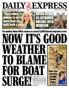
Now it’s good weather to blame for boat surge! The Daily Express says “now it’s good weather to blame for boat surge” as the paper mocks the Labour government’s comments. The new search for Maddie McCann has begun in Portugal. There’s coverage of a royal intruder breaking into Windsor Castle and an exclusive from Vanessa Feltz.
The UK front pages react to a new Home Office report that has linked the UK’s hot weather this year to a dramatic rise in the number of small boat crossings when compared to the same period last year. A record 11,074 people arrived in small boats before May this year, a rise of almost 50% compared with the same period last year.
The story leads two tabloid front pages this morning – both conservative-leaning.
The left-leaning press takes a more neutral tone compared to the sensationalist approach from the right.
Wednesday’s UK newspaper front pages offer a variety of headlines with no one story dominating the papers. A handful touch on the migrant channel crossings, in particular Labour’s theory that crossings have risen due to the good weather. But there is little unity across the papers and instead standalone reports ranging from war and conflict to the latest showbiz news.
The Met Office’s new Azure-based supercomputer aims to enhance 14-day forecast accuracy to levels comparable with current seven-day forecasts.
A yellow weather warning has been issued for thunderstorms, with the potential to cause flooding in parts of England and Wales, according to the Met Office.
The Met Office has issued a yellow weather warning for thunderstorms, predicting potential flooding and disruption across much of Wales and southern England.
Thursday could be the hottest day of the year so far and the warmest start to May on record.
The Met Office has issued a yellow warning for ice across parts of England, active from 3am to 9am on Thursday. The need to stay safe during these icy conditions is prioritised, and commuters are advised to take extra precautions when leaving their homes to minimize the risk of accidents. Met Office Issues Yellow Ice Warning for England As wintry weather persists, conditions are expected to remain chilly, with sleet and hail likely and snow…
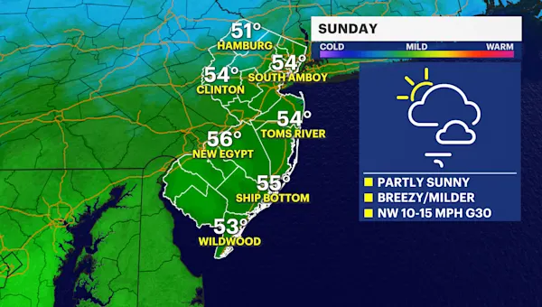
Cliff Notes Winter is officially ending in 11 days, with temperatures expected to rise significantly in the coming days. Gusty winds are forecasted today, with gusts up to 30 mph and mild temperatures reaching the low 50s. Starting tomorrow, temperatures will be 10-15 degrees above average, potentially hitting the 60s on Monday and Tuesday with clear skies and light breezes. Cooler temperatures are predicted for Wednesday and Thursday, dropping to the upper 40s/lower 50s, with…
Good Morning, Poland! Throw open those curtains as a wave of spring-like weather is sweeping the country. It’ll start getting chilly this evening, however, so make the most of the warm and sunny day. In global news, politics continues to dominate the conversation as European leaders are set to meet in Paris. The French President delivered a speech yesterday calling for Europe to unite, and Donald Trump is considering a u-turn on the pausing of…
The Met Office has issued yellow weather warnings through Tuesday Storm Herminia map: Where winds and rain will hit UK today as more bad weather follows Storm Eowyn A series of yellow weather warnings for wind and rain will continue through Tuesday after Storm Herminia caused disruption across large parts of England and Wales. The Met Office predicted heavy blustery showers and thunderstorms as it issued three weather warnings across the south of England and…
Showers or longer spells of rain across most areas. Showers turning heavy at times in the south with a chance of thunder, plus hill snow in the north. Strong, gale-force winds continuing in the south, and temperatures around average. Tonight: Showers and longer spells of rain continue overnight. Gales in the southwest slowly easing, but winds picking up in the far north. A patchy frost forming in the northwest.
Storm Éowyn will bring dangerous winds to Northern Ireland and parts of Scotland throughout today with heavy rain at times. After a wet and windy start further south, winds easing and becoming largely dry. Tonight: Destructive winds continuing in Northern Ireland and Scotland, especially in the far north, along with heavy downpours. Generally drier in the south. A colder night with frost in places.
Storm Eowyn: How rare are red weather warnings and what is the danger? A rare red weather warnings has been issued by the Met Office for Northern Ireland and parts of Scotland as Storm Éowyn is set to bring severe winds to the UK on Friday. The extreme weather event has seen hundreds of schools close in preparation, and dozens of rail operators halt their services. The storm marks the first time Northern Ireland has…
The Met Office has issued a red warning across Northern Ireland and Scotland Storm Eowyn map: Where and when snow and 100mph winds will hit UK after Met Office weather warnings issued Storm Eowyn is set to bring strong winds across the entire country, potentially putting lives at risk, the Met Office has warned. Gusts of more than 100mph with the small possibility of isolated tornadoes could cause power cuts, travel disruption and damage to…
Storm Eowyn tracker live: Rare ‘stay at home’ weather warning issued as dangerous 100mph winds pose threat to life Schools have been closed and people warned not to travel on Friday, as 100mph winds are set to pose a danger to life in parts of the UK. Rare red weather warnings will become active in Northern Ireland from 7am on Friday as Storm Eowyn is likely to damage buildings, uproot trees and cause power cuts, the Met…
All Northern Irish schools to close on Friday Storm Eowyn live: Tornado threat as Met Office issues red weather warnings for 100mph winds A tornado warning has been issued ahead of the arrival of Storm Eowyn set to batter UK’s coasts with 100mph winds this weekend. The Met Office issued a rare red warning across Northern Ireland and Scotland which will see winds rapidly during the Friday morning rush hour with peak gusts of 80-90 mph fairly widely…
Cold weather payment: Over 1m households set for £25 – postcode checker and eligibility Am I eligible for a cold weather payment? Pension CreditIncome SupportIncome-based Jobseeker’s Allowance (JSA)Income-related Employment and Support Allowance (ESA)Universal CreditSupport for Mortgage Interest When will I get the payment? Full list of postcodes eligible for cold weather payment Cold weather payment: Over 1m households set for £25 – postcode checker and eligibility https://www.independent.co.uk/news/uk/home-news/cold-weather-payment-dwp-postcode-checker-2025-b2684919.html
Frost and fog clearing, then a bright start for many. A band of wet and windy weather sweeping eastwards across most areas, followed by brighter skies with some blustery showers in the west but the late afternoon and evening.Tonight: Rain moves off to the east, leaving a mostly dry and clear evening across much of the UK. Storm Éowyn moves into the west by the early hours.
The Met Office has issued a yellow wind warning from midnight on Friday across most of the UK, including the south-west of England, the Midlands, northern England, Northern Ireland and Scotland Storm Eowyn map: Where and when snow and 90mph winds will hit UK after Met Office weather warnings issued Storm Eowyn is set to bring strong winds across the entire country, potentially putting lives at risk, the Met Office has warned. Gusts of more…
Morning fog patches across northern England and Northern Ireland, lifting with a mix of bright spells and scattered coastal showers. Rather cloudy and mostly dry elsewhere but outbreaks of rain and drizzle across the southeast of England. Feeling rather cold. Tonight: Rain in the southeast clearing. Otherwise, coastal showers continuing in places. Patchy fog and frost, most likely in the east. Colder than previous nights with more widespread frost further north.
A rather cloudy day across the central swathe of the UK with outbreaks of rain. Elsewhere, fog patches gradually lifting allowing some bright or sunny spells to develop, especially across Scotland and Northern Ireland. Temperatures near or slightly below average. Tonight: Band of patchy rain remaining slow-moving across central areas overnight. Increasingly cloudy to the south with some fog developing. Clear spells and a patchy frost developing across the north.
A band of rain across western Scotland will clear into northern England and northwest Wales throughout today. Rather cloudy to the south of this, although perhaps a few breaks developing. To the north a mix of bright spells and showers. Tonight: The band of patchy rain will stall across the central swathe of the UK overnight. Otherwise a mix of cloud and clear spells, with some fog patches developing.


