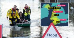
Heavy rain and flooding have already hit the south west of England and Wales (Picture: Alamy Live)
Weather warnings have been placed across the UK as more heavy rain and flooding will hit the country this weekend.
Yellow weather warnings have been placed across Wales and the west of England from 9pm today until noon tomorrow.
Northern Ireland will also see strong winds and heavy rain from tomorrow afternoon until the early hours of Sunday.
There are currently 258 flood alerts and warnings across the country, although Wales and the South West have already been hit, with many being evacuated from their homes.
The Met Office has warned the poor weather will lead to a disruption of services, with ‘the flooding of homes and businesses likely’.
Parts of north-west England, Northern Ireland and north Wales could see gusts of up to 70mph, alongside a dip in temperatures.
Forecasters also said it is likely power supplies will be affected, and journey times will be much longer due to the condition of the roads.
Meteorologist and presenter Aidan McGivern said: ‘It’s going to stay blustery, with some strong gusts in the west in particular and these lows will continue to send us outbreaks of rain and showers heading into the weekend.
There will be three weather warnings in place for much of tomorrow (Picture: Metro.co.uk)
Residents from Grey Friars, Hereford, have already been evacuated after their homes have been flooded (Picture: Alamy Live News)
To view this video please enable JavaScript, and consider upgrading to a web
browser that
supports HTML5
video
‘With all that wet weather coming in, there are concerns, particularly for those areas that have already seen so much rain across western England and Wales.
‘The wettest weather is likely to see 60 to 80mm falling across the Brecon Beacons and Exmoor.’
Snow is also expected to return as a cold snap hits the UK over the coming weeks.
Monday and Tuesday will see wintry showers and colder weather, with snowfall coming over the high parts of the country.
The Met Office has warned many services could be disrupted, including power supplies (Picture: PA)
‘Next week, the jet stream is a bit more amplified and it’s coming at the UK from the North West rather than from the west like recent days,’ Mr McGivern explained.
‘This subtle change into the start of next week will see colder weather coming in and rather than prolonged bouts of rain from the west, we’re likely to see rain and showers coming from the North West.
‘These showers from the North could fall as snow over the high parts of Scotland, northern England and Northern Ireland later in the weekend, and as we move through next week often below average temperatures could support a mixture of rain, hail sleet and snow.’
Get in touch with our news team by emailing us at [email protected].
For more stories like this, check our news page.
Wales and south-west England will be worst hit.


