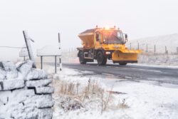
Snow has already begun to settle widely in Cumbria (Picture: Jordan Crosby)
An Arctic blast is set to plunge temperatures below -8°C in the coming days, bringing snow to the northernmost parts of the country.
The Met Office has issued a yellow weather warning for heavy snowfall in Scotland which is predicted to disrupt travel on Wednesday.
Roads and railways are at risk of blizzard conditions, with up to 10cm of snow in the Scottish mountains and 5cm in lower areas such as Aberdeen.
The first major snowfall of the winter settled in Cumbria on Sunday, where ploughs were called out to clear the roads.
Skies will remain clearer further south but virtually all the UK is expected to experience freezing weather as the week draws on.
‘Very widespread’ cold could bring temperatures as low as -5°C across swathes of England overnight on Thursday, the Met Office says.
It warned of an ‘increasing risk of some wintry hazards’ such as ice on roads and rail tracks caused by hard frosts at night.
Forecasts point to temperatures of -1°C spreading as far as typically warmer areas such as Cornwall and East Anglia.
To view this video please enable JavaScript, and consider upgrading to a web
browser that
supports HTML5
video
Temperatures will remain below freezing during the daytime on Thursday and get even colder towards the weekend, falling to -3°C in the West Midlands and parts of the North as workers head home on Friday.
The weather will remain freezing across the North, Midlands and East as pubs fill up for England’s World Cup quarter final fixture against France on Saturday.
Monday is expected to be milder, with average daytime temperatures of around 7°C.
The skies are likely to remain cloudy across much of England, with showers in the east spreading southeast later in the day.
A blast of cold air from the Arctic is set to fuel freezing weather across most of the UK this week
But the feed of colder air from the Arctic will quickly bring them down, reaching around 5°C on Tuesday and 3°C on Wednesday.
Alex Burkill, Met Office meteorologist, told Sky News: ‘At the moment we have an easterly flow and as such our winds are coming from the east and that is a cold direction, and it is cold out.
‘However, from Tuesday onwards we are going to get a northerly flow, so our winds coming from the north, that is Arctic air leading to our temperatures dropping even further as we go through this week.
‘It’s going to turn even colder and feel even colder still, with temperatures well below average for the time of year, both by day and by night.’
Get in touch with our news team by emailing us at webnews@metro.co.uk.
For more stories like this, check our news page.
A blast of cold Arctic air is set to bring lows of -8°C in Scotland and -5°C across large parts of England and Wales in the coming days.


