To view this video please enable JavaScript, and consider upgrading to a web
browser that
supports HTML5
video
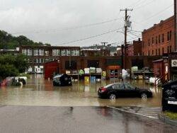
A devastating storm has moved up the northeastern United States, bringing torrential rain and destructive floods to Vermont.
Over 13million Americans were placed on flood watches or warnings as a deadly storm moved up the east coast on Monday night.
The floods in Vermont come just a day after severe flooding in New York’s Hudson Valley killed a woman who was trying to evacuate with her dog.
Parts of central Vermont saw as much as 9.05 inches of rainfall on Monday, the National Weather Service in Burlington reported the next day.
A car tries to navigate flooded streets in Montpelier, Vermont (Picture: Neal P. Goswami via REUTERS)
No casualties or injuries have been reported so far, but at least 117 people in the Green Mountain State were rescued by swift boat as rising floodwaters overwhelmed city streets.
Later in the day, rainwater raised the levels of the Winooski River, which runs through the state capital of Montpelier, to as high as 20.88 feet
‘This is a very serious situation,’ the NWS said. ‘Everyone in Montpelier and surrounding areas need to stay up-to-date on the river levels. Significant to catastrophic flooding is expected!’
According to the NWS, the Winooski rose as high as 20.88 feet.
A parking lot turns into a river in Hartford, Vermont (Picture: Danielle Vallone / TMX / SWNS)
The water level was higher than the floods caused by Hurricane Irene in 2011, and just inches lower than a record set in 1927.
The floodwaters were only six feet short of exceeding the capacity of the Wrightsville Dam, located only 4.5 miles upriver from Montpelier.
‘There would be a large amount of water coming into Montpelier which would drastically add to the existing flood damage,’ Montpelier Town Manager Bill Fraser said.
Drone footage from Montpelier and other cities in the region show streets completely flooded, even without the excess water from the dam.
Floodwaters pour over the dam on the Ottauquechee River, in Quechee, Vermont (Picture: VERMONT STATE POLICE via REUTERS)
‘I actually had to hike the Bass Trail to get to a drivable road to get to work this morning,’ the Vermont Governor Phil Scott said at a news conference on Tuesday.
Although the storms subsided in most of the Green Mountain State by Tuesday, the governor said the disaster is ‘nowhere near over.’
‘The good news is the rain has stopped in some areas, but that does not mean waters will immediately recede,’ the Scott said. ‘They may, in fact, continue to rise.’
He continued: ‘Even though the sun may shine later today and tomorrow, we expect more rain later this week – which will have nowhere to go in the oversaturated ground.’
Floodwaters rise above a home in Windham, Vermont (Picture: Scott Eisen/Getty Images)
Meanwhile, forecasters expect the slow-moving storm to move east through upper New England.
‘Persistent heavy rain will cause areas of flooding across New Hampshire and western Maine tonight,’ the NWS in Gray, New Hampshire said on Monday night. ‘Minor to moderate river flooding is possible in New Hampshire river basins.’
President Joe Biden, who is currently in Vilnius, Lithuania for the NATO summit, signed an emergency declaration and authorized the Federal Emergency Management Agency (FEMA) to coordinate disaster relief.
Got a story? Get in touch with our news team by emailing us at [email protected]. Or you can submit your videos and pictures here.
For more stories like this, check our news page.
Follow Metro.co.uk on Twitter and Facebook for the latest news updates. You can now also get Metro.co.uk articles sent straight to your device. Sign up for our daily push alerts here.
Parts of central Vermont saw as much as 9.05 inches of rainfall on Monday.


