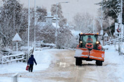
The Met Office has already issued weather warnings this week, but things could get worse (Picture: Jeff J Mitchell/Getty Images)
The UK weather has been particularly trying this week, with temperatures well into the minuses and weather warnings issued across parts of the country.
Just when you thought it couldn’t feel chillier or de-icing your car in the morning was the worst of it, a snow bomb has been predicted.
A snow bomb – or a weather bomb – is reportedly heading to the UK, and, as the name might suggest, it’s not exactly the best news.
What does it mean?
What is a weather bomb?
A weather bomb is an unofficial term for a low pressure system whose central pressure falls rapidly within a short amount of time, causing violent winds and adverse weather conditions.
Per the Met Office, a ‘weather bomb’ can be defined when a low pressure system’s central pressure falls 24 millibars in 24 hours. This process is known as explosive cyclogenesis.
To view this video please enable JavaScript, and consider upgrading to a web
browser that
supports HTML5
video
Rapid acceleration of air caused by the jet stream high up in the atmosphere can remove air from the column, reducing its weight so causing pressure to fall at sea level. This in turn sucks in air which converges from surrounding regions resulting in faster and faster rotation of the circulation.
The snow comes in when we look at the longer forecasts from advanced weather maps from WX Charts.
This system indicates a blizzard will make landfall in Northern Ireland and northern parts of Scotland on the evening of Thursday, February 2.
This will then eventually spread to most of the UK, covering huge swathes of the country with heavy snow.
Areas of the UK have seen snow this week, but the weather bomb could be much larger (Picture: Jeff J Mitchell/Getty Images)
According to the Daily Star, Netweather’s forecaster Nick Finnis said that a ‘high latitude blocking towards Greenland’ will bring a ‘NAO’ towards the UK.
An NAO is a North Atlantic Oscillation, something which brings cold air towards us in a negative phase, resulting in heavier precipitation, like snow and sleet.
Finnis said: ‘Colder conditions may spread south with a wintry risk to all parts briefly on the back of low pressure systems moving east and high pressure building to the west.’
Some are even calling it a ‘polar vortex’ with meteorologist Jim Dale telling the Express: ‘Only stratospheric warming over the North Pole will keep us and other northern hemisphere countries in the wintry frame through February.’
‘It’s begun but it needs to continue, for the Polar Vortex to split and then we see where it goes.’
MORE : Fresh ice warnings across UK while Scottish ski slopes are forced to close
MORE : What do the iPhone weather symbols mean?
Follow Metro across our social channels, on Facebook, Twitter and Instagram.
Share your views in the comments below.
Find out what a weather bomb could mean for the UK


